Lidar (Light Detection and Ranging) is a powerful remote sensing technology that uses laser pulses to measure distances. It’s primarily used to create highly accurate 3D models of environments, making it a valuable tool in digital mapping, topography, and wayfinding.
Understanding LiDAR Technology
LiDAR scanners work by emitting laser pulses and recording the time it takes for the light to bounce back after hitting an object. The data is then used to generate precise, three-dimensional representations of physical spaces. Unlike traditional mapping methods, which can rely on human interpretation or GPS signals, Lidar offers a higher degree of accuracy and granularity.
- How it Works:
- Laser Emissions: LiDAR sensors emit rapid laser pulses at the target.
- Data Collection: The time taken for the laser to return gives an exact measurement of distance.
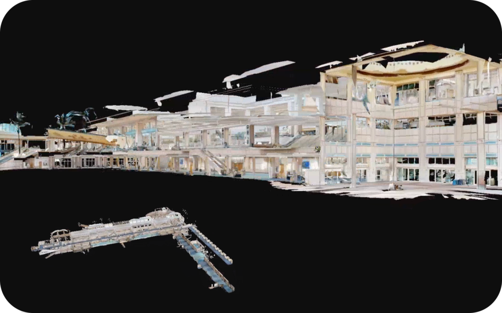
- Point Clouds: The result is a “point cloud” that creates a 3D map of the environment, capturing intricate details such as textures, shapes, and topography.
LiDAR’s Value in Digital Mapping and Wayfinding
LiDARtechnology provides incredible accuracy, even in complex environments. This is crucial for creating precise indoor and outdoor maps, and for developing navigation systems that can guide users through intricate spaces like airports, shopping malls, and large commercial properties.
- Precision: LiDAR captures data with millimeter precision, ensuring highly accurate maps and layouts.
- Real-time Data: It helps map physical spaces as they exist at the moment, which is particularly useful for updating maps and ensuring that any changes, such as renovations or relocations, are quickly reflected.
- Environmentally Inclusive: LiDAR can map difficult environments that GPS can’t, such as indoor spaces, areas with limited visibility, or places with dense vegetation.
The ROI of LiDAR in Digital Mapping and Wayfinding
Investing in LiDAR technology offers significant returns, particularly in sectors like infrastructure development, urban planning, and facility management. For instance, a case study highlighted in GIM International showcases how reality modeling, including mapping underground utilities prior to design, saved $521,000 in project costs by eliminating utility conflicts and resulting change orders. (geospatial.blogs.com)
Additionally, the Virtual Singapore project, which employed LiDAR for comprehensive 3D city modeling, demonstrated the value of LiDAR in creating detailed digital twins for urban planning and disaster management. (en.wikipedia.org)
Incorporating LiDAR into mapping and wayfinding solutions can lead to improved operational efficiency, reduced costs, and enhanced user experiences, making it a sound investment for businesses and municipalities alike.
How MapVX Leverages LiDARTechnology
MapVX is at the forefront of leveraging LiDAR scanners for creating interactive digital maps and wayfinding solutions. By integrating LiDARtechnology into its offerings, MapVX helps businesses like shopping centers, airports, and large commercial real estate properties to enhance customer experiences, operational efficiency, and navigation.
- Indoor Mapping & Navigation: For example, MapVX uses LiDAR to map indoor spaces in 3D, providing users with precise turn-by-turn navigation through malls, airports, or large buildings.
- Real-time Map Updates: As LiDAR scans update the environment’s spatial data, MapVX ensures that real-time changes are reflected in the digital maps, providing the most current information for users.
- Enhanced User Experience: With LiDAR-powered wayfinding, customers can seamlessly navigate complex indoor and outdoor environments, improving their overall experience.
Real-World Examples of Lidar in Action
- Airports: LiDAR is used to map and navigate vast and complex airport terminals, improving the passenger experience with clear, intuitive wayfinding and real-time updates on gate changes or amenities.
- Shopping Centers: Large malls benefit from Lidar scans to create interactive directories that help customers quickly find stores, restrooms, and other amenities.
- Real Estate: Commercial real estate companies use Lidar to create accurate 3D floor plans and enhance their virtual tours, providing potential tenants with a detailed layout of properties.
The Future of Lidar and Digital Mapping
As LiDAR technology continues to evolve, its integration with AI and other advanced tools will only improve. The future of mapping and wayfinding lies in combining Lidar’s precision with real-time analytics, AI-driven recommendations, and multi-platform accessibility.
- Increased Integration: Expect to see more seamless integrations between Lidar and mobile apps, allowing customers to navigate with ease.
- AI-powered Insights: The combination of LiDAR and AI analytics will lead to smarter, more adaptive maps that change based on user behavior and environmental factors.
Conclusion
LiDAR scanners are a game-changer in the world of digital mapping and wayfinding. Their ability to provide precise, real-time, 3D models makes them invaluable for businesses seeking to improve navigation in complex environments. MapVX leverages LiDAR technology to offer unmatched accuracy and efficiency in mapping solutions, enhancing the customer experience and providing businesses with powerful data to optimize their operations.